


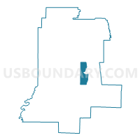
Voting District 030002, Livingston County, New York
About
Outline

Summary
| Unique Area Identifier | 629581 |
| Name | Voting District 030002 |
| County | Livingston County |
| State | New York |
| Area (square miles) | 10.45 |
| Land Area (square miles) | 9.66 |
| Water Area (square miles) | 0.79 |
| % of Land Area | 92.47 |
| % of Water Area | 7.53 |
| Latitude of the Internal Point | 42.70403710 |
| Longtitude of the Internal Point | -77.70200170 |
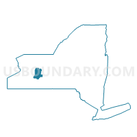
Maps

Graphs
Select a template below for downloading or customizing gragh for Voting District 030002, Livingston County, New York


Neighbors
Neighoring Voting District (by Name) Neighboring Voting District on the Map
- Voting District 030001, Livingston County, NY
- Voting District 040008, Livingston County, NY
- Voting District 050001, Livingston County, NY
- Voting District 050002, Livingston County, NY
- Voting District 080003, Livingston County, NY
- Voting District 080005, Livingston County, NY
- Voting District 140001, Livingston County, NY
- Voting District 140002, Livingston County, NY
Top 10 Neighboring County Subdivision (by Population) Neighboring County Subdivision on the Map
- Geneseo town, Livingston County, NY (10,483)
- Livonia town, Livingston County, NY (7,809)
- Groveland town, Livingston County, NY (3,249)
- Conesus town, Livingston County, NY (2,473)
- Sparta town, Livingston County, NY (1,624)
Top 10 Neighboring Place (by Population) Neighboring Place on the Map
Top 10 Neighboring Unified School District (by Population) Neighboring Unified School District on the Map
- Geneseo Central School District, NY (11,525)
- Livonia Central School District, NY (10,900)
- Dansville Central School District, NY (10,145)
Top 10 Neighboring State Legislative District Lower Chamber (by Population) Neighboring State Legislative District Lower Chamber on the Map
Top 10 Neighboring State Legislative District Upper Chamber (by Population) Neighboring State Legislative District Upper Chamber on the Map
Top 10 Neighboring 111th Congressional District (by Population) Neighboring 111th Congressional District on the Map
Top 10 Neighboring Census Tract (by Population) Neighboring Census Tract on the Map
- Census Tract 307, Livingston County, NY (7,809)
- Census Tract 308, Livingston County, NY (5,922)
- Census Tract 302.02, Livingston County, NY (5,843)
- Census Tract 311, Livingston County, NY (4,912)
- Census Tract 313, Livingston County, NY (4,486)
Top 10 Neighboring 5-Digit ZIP Code Tabulation Area (by Population) Neighboring 5-Digit ZIP Code Tabulation Area on the Map
- 14437, NY (11,415)
- 14454, NY (11,073)
- 14487, NY (6,025)
- 14435, NY (2,941)
- 14462, NY (655)
- 14545, NY (173)